It was 11 am on September 3rd 2018, I was 1 mile away from Whitney Portal (WP) when I came across a Gentleman going up with what seemed like a single liter of water, wearing a cool short and a t-shirt, with some snacks in the pocket. I stopped for a minute and this is how our conversation took place:
Me – How are you?
Gentleman – I am good, how are you?
Gentleman – How much more?
Me – Confused, asked if it was to Lone Pine lake (an ideal location for day hike), about 2.5 miles away!
Gentleman – No, to the summit.
Me – **Shocked** About 10 more miles and 6000 ft up!
Gentleman – Thank you.
After this candid conversation I continued on my hike down to WP, where Robert who agreed to pick me and my friend from the portal, and drop us back at Tuolumne Meadows (TM) campground was waiting with his Lexus. This is when it stuck me; I was on the trail for 16 days, carrying an oversized backpack for my weight which no longer felt heavy, thinking about not showering for 13 days, and more than 10 blisters on my feet that were all Leukotaped, and the best feeling in the world of having experienced the John Muir Trail from TM to WP. John Muir rightly said “In every walk with nature one receives far more than he seeks”, and that is exactly how my experience was!
My incredible journey started on August 17th 2018. I was all set to travel in the evening after work, and all I could think of was how the next 18 days of my life would unravel. I was supposed to pickup my friend and head out to explore what we were waiting for the last 10 months.
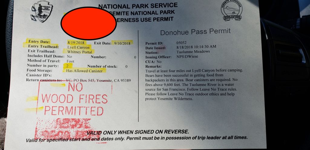
Day 0 – After spending the night in Groveland, in what was supposed to be the last night on a proper bed for the foreseeable future we started driving towards TM to pick up our permits. This was the first week Yosemite was reopen after Ferguson fire so there was little traffic getting into the park even on a Saturday. Our initial plan was to pick up the permits and start hiking the same day, even though our permits were supposed to start a day later. We arrived at the TM ranger station and picked up our permits. The ranger gave us a run down on everything we needed to know, and told us we could not start the hike until tomorrow (which is when our permits were valid from). We had to wait one more day to get on the trail, and the next 24 hours were harder than the last 10 months of preparation and procrastination we endured.
With our permit in hand we spent the day doing a small hike and ended up spending the night at TM backpackers campground.
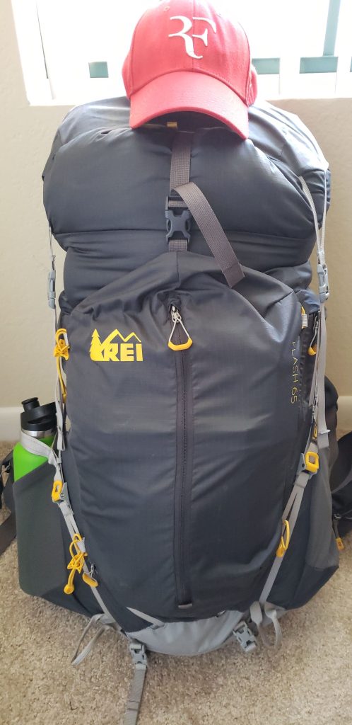
Day 1 – Finally the day had arrived, and the quest to get on the trail and experience the nature was upon us. Our day started with an adventure of knowing how to lit our tiny little stove. I was in-charge of carrying the stove and everything with it, but never mastered the art of lighting it! We eventually ended asking a friendly neighbor and it was the easiest thing one could never forget. With much anticipation of getting on the trail we prepared to weigh our bags for one last time, and realized it was way too heavy than we had anticipated. We knew our bags would be heavy, and we had trained with the same backpacks and with similar weights, but all the extra gear, additional clothes were wearing us down. We decided to cut down on all the non-essentials and that was the second best thing we could do in reducing our overall backpack weight. We gave up our luxury items that included hydro flask, extra clothes, unwanted gear and every small thing that seemed unnecessary.
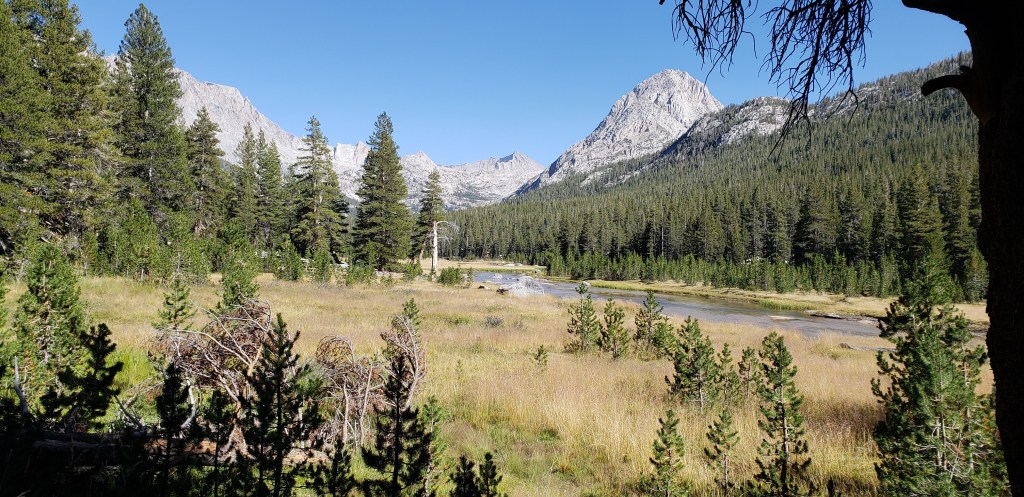
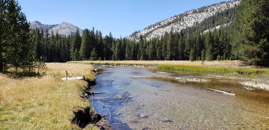
After our backpack shakedown, it was finally time for us to begin the journey! We exited the TM backpackers campground from the back and joined the JMT. Shortly into our hike we realized that the extra weight would have definitely made a lot of difference. The hike from TM runs through a very flat stretch until you reach the base of lower Lyell canyon. We were very thankful to have started from TM as our backpacks were definitely heavier the first day, and it was the very first time we had a full weight backpack.
About 2-3 miles into the hike we ran across a couple of rangers who checked our permits and made sure we were carrying bear canisters. Slowly and steadily we adjusted our backpacks after our permit check and proceeded on the trail. The trail was absolutely deserted and we were the only ones on it until we reached the Vogelsang junction. This is where we took our first break for the day, removed our shoes and had our snack-lunch. Our backs were thankful, and the feet really appreciated the break. We spent a good 30 minutes for our break and got back on the trail.
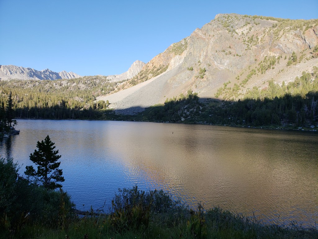
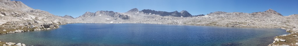
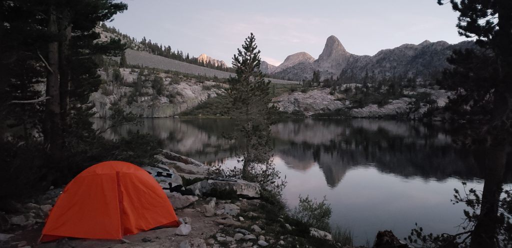
The clock stuck noon, and we had good pace covering the flat stretch. We got over ambitious and started making plans to go beyond our planned camping destination; which was at the foot of Lyell fork crossing facing Mount Lyell. We slowly started picking up elevation and realized what a loaded backpack and elevation can do to us. Our pace that was steady seemed to have come down, and we were no longer hiking but snail-ing. Slow and steady we kept our pace and reached our first camping spot and decided not to go further. It was a wise decision as we needed time to setup camp for the first time, and our body really appreciated the break.
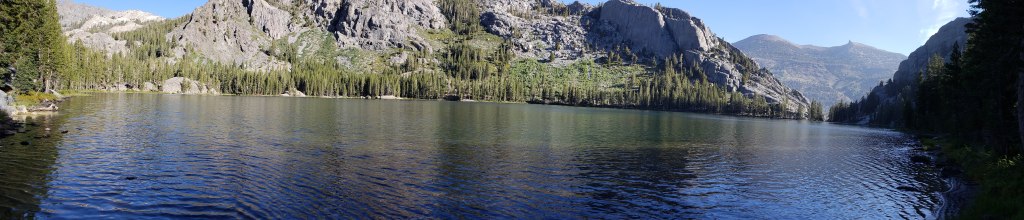
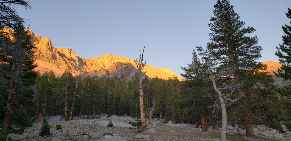
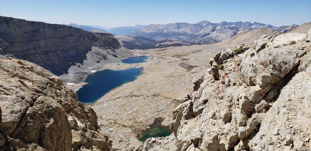
We reached our campsite around 4:30 pm which gave us ample time to setup the camp, but the most important thing was it gave us the perfect spot to camp. There was one other group camping at the same location and they were happy to accommodate us next to them. Three other groups came in about an hour later and found spots to camp, but nothing like the view below.

As the sun was setting down we wrapped up our photo sessions and started to get ready for our dinner. Breakfast and dinner were probably the most awaited times throughout our hike as we got to eat some hot food (who wouldn’t appreciate it)! As we finished our dinner, the winds started to pick up and the temperatures were getting cooler. We finished our business of digging cat holes for our morning ritual and went to sleep.
Day 1 Summary ~ 10.5 miles, 1500 feet elevation gain
Day 2 – We never really did need an alarm to wake up, but then we did a-customize ourselves to our daily alarms to wake us up in case we ever overslept. Day in and day out we were always the last to be on trail. By the time we woke up, all other campers were done with their breakfast and getting ready to move! We took our own sweet time and always left our camp between 8:30 to 9 am!
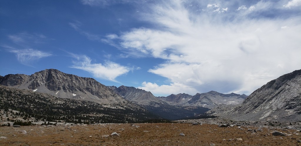
It was a gorgeous morning with sun shining brightly and the mountains standing tall like there was no place else to go. As we started to get going this is where we crossed paths with the “Purple Zombies”. They were trail named Purple Zombies because of their purple bags. We crossed Lyell fork and headed towards our first pass on the trail; Donahue Pass. From the fork the trail takes a steep turn and climbs up 1000 feet before reaching Donahue Pass. Our trail from Donahue pass was all downhill until we reached the junction of Rush Creek Trail.
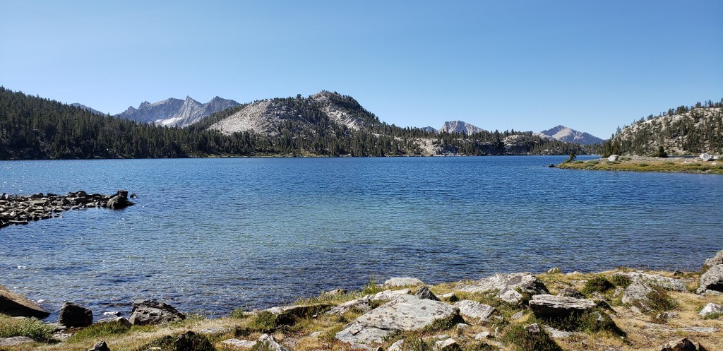
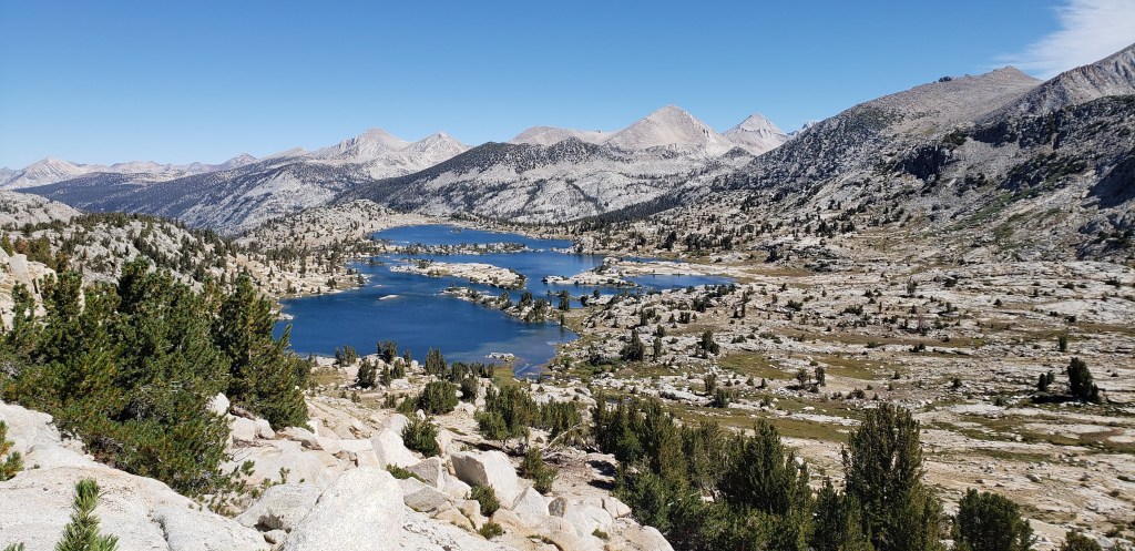
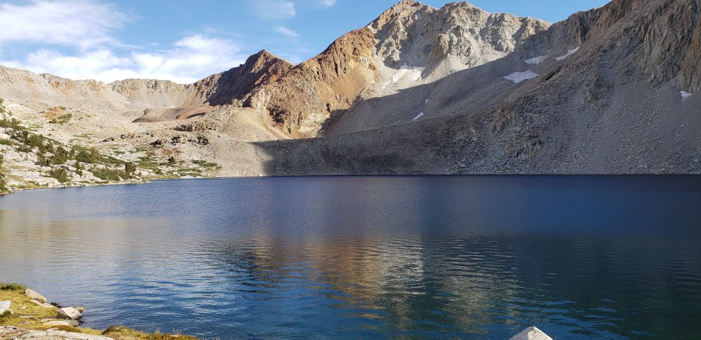
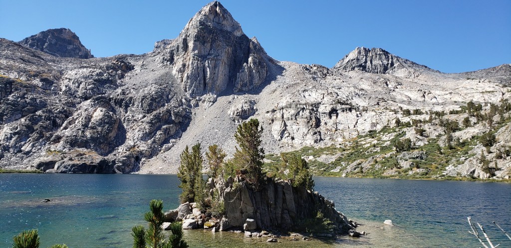
We took our day break at Rush Creek Trail junction and headed towards a mysterious pass named Island Pass. I call it mysterious because you never realize when you cross the pass and what lies beyond the pass is simply breathtakingly beautiful. As we descended Island pass we could get a glimpse of the magnanimous Banner Peak and were getting close to the beautiful Thousand Island lakes. As we continued on the trail for about a mile, we finally got to see the famous thousand island lakes in its full glory. We took a photo break where the view of thousand island lakes with banner peak at the back was the best, and then started going down the trail.

JMT and PCT split here at the thousand island lake outlet. We knew we had to stick to JMT and eventually get to Garnett Lake which was our camp site for the day. First up after thousand island lakes was Emerald Lake where you can detour and reach Garnett lake. We stuck to JMT and headed towards ruby lake. We were getting tired for the day and decided to take another break at Ruby lake. Ruby lake was the place where we had our first enlightenment tip from a couple who were hiking NOBO, and were almost close to finishing their hike. Here is the tip; “Carry only as much water as you need. There is so much water on the trail, you are never too far (except for where its explicitly called out in maps) from a water source”. This tip saved us some extra weight we were carrying around, and made our backpacks a little lighter. This is also the place, where I decided to not filter water, thanks to my inspiration from David!
After our enlightenment, we proceeded towards Garnett lake. The trail from thousand island lakes to Garnett Lake is uphill, until you get to the views of Garnett Lake. Our initial plan was to camp at the first campground at Garnett Lake, but we were tempted to cross the outlet and camp on the other side.
Another rookie mistake was in the making, as we crossed Garnett Lake and headed towards a camp site. There were already 2 groups camping, and we wanted to find a more spacious campsite so headed further in search of our campsite for the day. We had already put in about an extra mile for the day and the sun was setting on us. We hiked further for about another mile or so before we could find a camp site, but there was no water accessibility. At this point our feet were literally dragging, our souls were hurting, and our backs screaming and yelling at us to stop for the day. In search of water and loosing sun light we started to slowly walk towards the next water source which was at Shadow creek crossing.
We finally reached our campsite at 8 pm when it was almost dark. This was the only day we setup our camp using our flashlights and had our dinner in the dark. This was the day we decided, we will never stretch our day beyond 6 pm, so we can give enough time for ourselves to camp and have peaceful dinner. We went to sleep so exhausted that we were afraid we would not wake up the next day!
Day 2 Summary ~ 14.5 miles, 2200 feet elevation gain
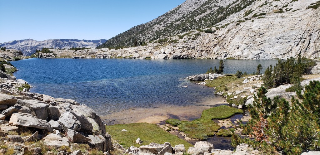
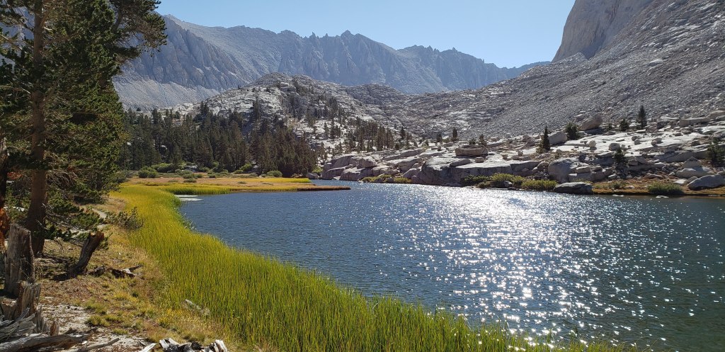
Day 3 – With an exhausted Day 2 behind us, we were ready to get on the trail after our morning routine. About half a mile into the hike, I started feeling first signs of blisters, and they were going to be my BFF’s for rest of the trail. We continued descending down until we reached Shadow Lake. There isn’t any camping around Shadow lake, and its for a reason, there isn’t any room between the trail and the lake for people to be camping here. Shadow lake was serene and calm and we enjoyed walking past it only for a moment, until we realized what was ahead of us.
The trail ascends about 600 ft in the next 2 miles through a series of gradual steep switchbacks until we reached Rosalie Lake. We continued powering through from Rosalie lake as we were determined to reach Red’s Meadow before the restaurant services were closed. The trail ascends for a mile or so from Rosalie lake before reaching Gladys Lake. By the time we reached Gladys lake, my blisters were bothering me too much and we decided to take our morning break a little early. As we sat down by Gladys lake, my partner was munching on his breakfast as I was taping my blisters for the first time. The first couple of blisters I had were on both feet, right beneath my phalanges and were more painful for walking. As I taped them up, the thought of not making the entire trail did cross my mind, but I decided to shut it down and continued to enjoy the trail than thinking about not making it.
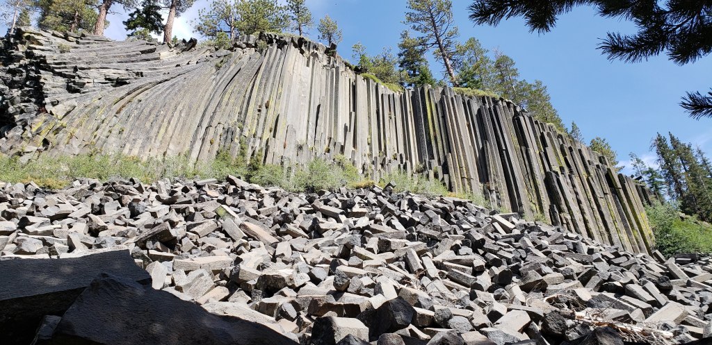
We continued on the trail after our morning break and were soon on the descent towards Reds Meadow. The descent was not shaded, but was helpful on the knees, not so much on the blisters. We entered Devils Postpile National Monument around 2 pm. From this point the trail ascends for a bit, before reaching the junction with Reds Meadow turnout. We had planned our first food pick up from Reds Meadow, and couldn’t wait to get there and relax for the day. As you head towards Reds Meadow you cross a foot bridge and head towards Devils Postpile National Monument. We went past the monument and reached Reds Meadow around 3:30 pm.
Our first order of business at Reds Meadow was to check if our food bucket made it without any problems. We walked into the Reds Meadow store and retrieved our food bucket and started our food sorting and packing for the next four days. Given that we were already on the trail for 3 days, we knew how much food we were consuming and the food we shipped was way too much for 2 people. We ended packing only half our food, and decided to leave the other half for fellow hikers. Once we were done with the packing we took our turns to take showers and laundry our dirty clothes before we could head into the famous restaurant and have the most awaited burgers and milk shakes. As I waited for my buddy to complete his chores, I ran into 2 other trail friends known as the “Boston Guys” who we would meet along the trail for next few days.
It was about 6 pm before we could go into the restaurant and have our food. Throughout our preparation and the countless blogs I have read, and all the people that we met on the trail (going NOBO), there was one thing everyone enjoyed, the burgers and milkshakes at the Reds Meadow restaurant. Though they were not the best burgers that I have had, they certainly lived up to the expectation. As we finished our dinner and headed out, we saw the “Purple Zombies” enter the restaurant and we proceeded towards our camping site. We ended up taking the bus to the campsite, as my blisters were troubling me, and I did not want to walk down after the heavy meal.
The night we spent at Reds Meadow was may be the most eventful night throughout the trail. As we reached the backpackers campsite a fellow hiker had already camped, and offered to share the campsite fee with us. Soon, another fellow hiker joined the site, and before we knew, we were making our introductions to the Purple Zombies. The first hiker we met was kind enough to lite a campfire for us, and we appreciated the warmth. There were numerous photo sessions, some crazy talks and a night full of stars that made the night eventful. I was the first one to hit the bed, and the rest of the folks followed into their respective tents in the next hour our so. We went to bed much more relaxed and were prepared for the next day!
Day 3 Summary ~ 12 miles, 800 feet elevation gain
Day 4 – It was a chilly night which made getting up in the morning not so fun. By the time we were ready to hit the trail the sun was already shining brightly on us and it was close to 9 am. Our backpacks did not weigh much more than the previous day, as we had carried extra food the first 3 days, and now were well prepared to carry the right amount of food. Reds Meadow is the lowest point on the trail at 7630 ft, and we knew our day was going to be a challenging one. The trail started to ascend from the get go, and we were walking through open forest area for the first 2 miles or so.
We started to gain more elevation as we crossed the open area and reached shaded section of the trail. Our first point of stop for the day was Deer Creek trail junction and we made it there in good time. It took us about 3 and half hours to reach Deer Creek trail which was about 5.5 miles from Reds Meadow resort. We took a break, and had our afternoon snack before we could head further. Our first break was also the time where I would re-tape all my blisters for the day, which was my daily routine for the rest of the trail. The number of blisters needed re-raping increased each day. There is no water between Deer Creek Trail and Duck pass trail, so while I was re-taping my blisters, my buddy was busy filtering water.
We filled our water bottles and continued on the trail. The trail was flatter for first mile or so after Deer creek trail junction, and ascends gradually until Duck Pass Trail. Except for the shaded trees and the trail, there are no lakes or water sources until you reach Duck Pass trail. Being on the trail and going through these uneventful stretches is more of a mental challenge than a physical one. It took us about 4 hours to reach Duck Pass trail and we were exhausted by then. We re-connected with the Purple Zombies at this junction and continued along the trail for the rest of the day.
The section of trail from Duck Pass trail ascends for about 300 to 400 ft, before descending down towards Purple Lake. By the time we ascended the trail from Duck Pass junction, it was getting tiring and we could not wait to camp for the day. Purple Lake is a mysteriously appearing lake, as the descend towards the lake seemed like a never ending hike, and lake is not visible until you get there. My blisters were continuing to bother me, so I was lagging behind. By the time I got to Purple Lake my buddy had found a tiny little perfect spot by the lake. We quickly made our tent and had our dinner going, before it could get dark.
I had to do something with my blisters, which is when I went to the Purple Zombies for advice as we were talking about them earlier in the day. As I was walking towards their campsite a fellow camper noticed my walk and knew what my problem was. He was kind enough to loan me a strip of Leukotape, which was magic to those blisters. The advice I got from Purple Zombies was to take my knife, slit my blister open, apply Neosporin and tape it. While I seemed hesitant at first, this worked out great and was my routine for any blister that popped up. As we discussed our next day plans, this is where Purple Zombies realized they had similar plans, and would camp along with us until the last day on the trail. I got back to my campsite and we finished our dinner and went to bed!
Day 4 Summary ~ 13.7 miles, 2800 feet elevation gain
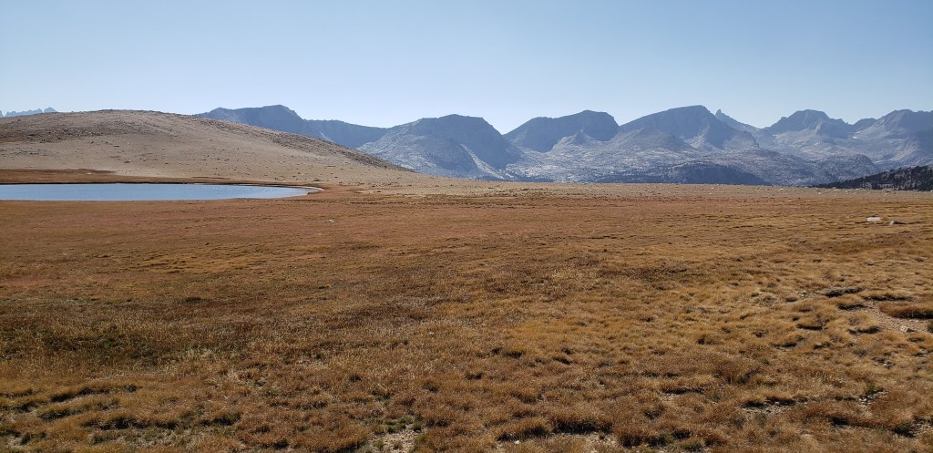
Day 5 – I woke up to much more relaxed feet as I had slit my blisters and drained them out the night before. As usual being the lazy ones, we started our hike closer to 9 am, well after everyone was on the trail for the day. Our first stop for the day was around Lake Virginia, and it did not take us long to get there. We took a short break to enjoy the views at Lake Virginia and proceeded further on the trail.
About half a mile past Lake Virginia, the trail descends through a series of switchbacks until you reach Tully Hole. This part of the descend is not shaded and we had to step aside a few times to give way to mule packers that were helping a group of people on their trip. We decided to continue further from Tully Hole before breaking for our lunch, and eventually ended up resting at the Fish creek footbridge.
We took a break for about 30 minutes before we could head further. Our usual goal for everyday was to get above the passes before noon so we don’t get caught in unexpected thunderstorms in the Sierra, which we only accomplished 2 or 3 times. From Fish creek footbridge, the trail gradually ascends through shaded area, before you have to make your final ascent towards Squaw Lake. Squaw lake was beautiful and refreshing, given that we were getting tired by the time we got here my buddy decided to dip in the water at Squaw lake while I sat down and enjoyed the beauty of the lake and its surroundings.
We spent a good part of 45 minutes at the lake before ascending our way towards Silver Pass. The trail ascends for about 500 to 600 ft in 1.5 miles from Squaw Lake before reaching Silver Pass. We reached Silver Pass right around the time when Purple Zombies were on the pass, and took a few pictures. There were quite a few people we met on Silver Pass who were either doing NOBO or part of the trail.
After taking a quick break at Silver Pass we descended down towards Silver Lake. The trail took a sharp descent towards Silver Lake and continued flat for the next 1.5 miles before reaching a section of steep switchbacks which we had to descend as the sun was setting down. The descent on these switchbacks was slower and we were losing sunlight quickly which made us re-evaluate our camping option for the night. Our original plan was to camp at Mono Creek trail junction, but we ended up camping at Mott Creek Trail junction. We quickly setup camp, and started to cook our dinner. We were camping next to Purple Zombies and this was our routine for the next 8 days. It was about 8 pm when we decided to hit the bed!
Day 5 Summary ~ 11.3 miles, 2100 feet elevation gain
Day 6 – This will go down as a day which had no photos, no passes, but a grueling hike. As usual we woke up around the time when everyone else was either on the trail or getting started on the trail. We knew our initial part of the hike would be a descent so were well prepared for it. We started off by descending towards Mono Creek trail junction. As we descended I turned on my cell phone to search for possible network connections, and I was in luck! I took a brief break to call my Wife and talk with her for a few minutes before I proceeded further.
At about 2.5 miles into the descent we crossed paths with VVR junction. I had spent the better part of our evening for the last 2 days convincing my buddy to skip VVR so we could save a day! If you want to get to VVR, you will need to reach this junction when the ferry runs, so you can avoid the 6 mile hike to VVR resort. A half a mile past the VVR junction is where we started our dreadful ascent on Bear Ridge. About a mile from the VVR junction is the last source of water for the next 5 miles, so we filled up our water and started our ascent. My problem with blisters continued and I had to stop in between to perform my blister surgery, so I could proceed without too much friction.
We took a short break while I was re-taping my blister and proceeded towards our ascent. We never really ran into clouds or rain until this point, but then we met “Lightning and Thunder”, half way through our ascent. This was not the Lightning and Thunder that included a rain, these were the trail names given to a couple of trail friends who were doing the JMT along with us, but were pacing through the trail at speed. We would meet them again at the end of the day, but then would not cross paths until the next 7 days. The ascent up over Bear Ridge was exhausting, and I was hiking alone for the most part as my buddy raced over to catch up with the Purple Zombies. I ended up meeting my buddy at the Bear Creek trail junction where he decided to cleanse himself in the creek.
About half a mile past the Bear Creek trail junction I caught up to my buddy who was relaxed, and the Purple Zombies who were now hiking along with my buddy. We continued on the trail together for the next 2 miles before departing each other at the junction of Lake Italy Trail. From Lake Italy trail all four of us split, and took varied pace as we made our final ascent for the day before reaching Rosemarie Meadow. Me and my buddy eventually ended up reaching about 20 minutes before the Purple Zombies and scoping out our camping location for the day. Our trail friends Lightning and Thunder crossed us and went up ahead to find a different camping spot, and this was the last time we would see them for a very long time.
As we prepared to camp at Rosemarie Meadow we were camping close to a couple who were already relaxing for the day. We eventually learnt that they were doctors from Australia who were on a year long trip, and were doing JMT as part of their vacation. You will be amazed by the various people you meet on the trail, and this was a testament to that fact. We talked to them for quite some time about their experience so far, and gave them their space once we setup our camp. There was still daylight left as we prepared to eat our dinner and end our rather uneventful day!
Day 6 Summary ~ 12.5 miles, 2900 feet elevation gain
Day 7 – Today is the day, we officially got our trail names, and they were not bestowed upon us until we camped for the night! Per our routine normal, we started our day around 9 am. It was supposed to be a long day for us, as we were supposed to pick up our last resupply and head further along the trail. About a mile into our hike we met another trail friend who was doing a section hike alone. This trail friend became our epitome of willingness to hike even in our late 60’s. We had a good chat and proceeded towards Selden Pass.
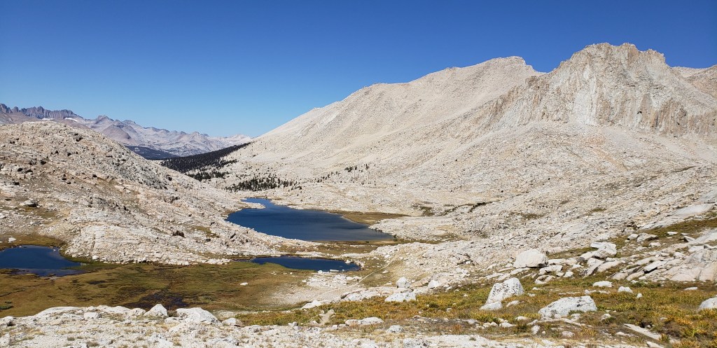
About 2.5 miles into the hike we ended up at the beautiful Marie Lakes. We heard so many people talk about how beautiful Marie Lakes were, and did not realize this until we saw it with our own eyes. The panoramic views were absolutely stunning, with Selden Pass in vicinity. We spent a good amount of time at Marie Lakes, before heading towards Selden Pass. Selden Pass is probably the most beautiful pass that we had crossed until today, and the views from top were breathtakingly beautiful.
We started descending down from Selden Pass after enjoying our solidarity for a brief time. The descent down Selden Pass is small and is beautiful on either side, with Heart Lake views getting better as you descend down. We went past Heart lake, and Sally Keyes Lakes as we continued to gain pace on flatter sections of the hike. About a mile past Sally Keyes Lakes, we decided to take a break. From this point on, I would not see my buddy until we reached the descent towards Muir Trail Ranch (MTR). My buddy had two reasons to leave me today, one my slow pace, two the yummy Salmon he had from the Purple Zombies the day before was tempting him for more of that food, and he was in a hurry to catch them up on the trail. The trail had a brief uphill before reaching the JMT halfway point and was all downhill from that point.
The downhill was brutal as we had to descend close to 2000 ft before ending up at MTR. The descent towards MTR seemed like never ending as we crossed a number of switchbacks before reaching the diversion towards MTR. We reached MTR right around the time Purple Zombies reached the resupply point. Our first business for the day at MTR was to get our resupply buckets and sort our food for the next 9 days on the trail. This was supposed to be our last resupply point, and we were supposed to carry all our food in the bear canister. We had to do several rounds of rationing to fit the right amount of food for 9 days, and ended up sending half of our energy food back home using a flat rate box from MTR. We also shipped several other things that we had not used in our back pack, to reduce our overall backpack weight. I eventually ended up buying a pair of sock liners and the most amazing thing called “Leukotape”, both of which were blister savers after that day.
It took a good 90 minutes for us to sort all our food, and stuff ourselves with all the other food people were leaving for other hikers. Our original plan was to go up until Piute Pass trailhead, but we decided to not stretch it and camp about a mile or 2 further from MTR. We proceeded along with the Purple Zombies and camped by a stream right before joining back the JMT. Me and my buddy decided to clean ourselves in the stream as there was enough daylight left. As we prepared our dinner, we were honorarily bestowed our trail names and were called “The White Walkers”, as we would always end up catching up to the Purple Zombies by the end of the day. The night was peaceful, and we were happy that we had passed the halfway point and were left with the remaining half.
Day 7 Summary ~ 10 miles, 1000 feet elevation gain
Day 8 – This was probably the only day we actually needed an alarm to wake up. We had a good night sleep and were ready to hit the trail with our overweighing backpack. Though the backpack was heavy we had our trail legs on, and were in much better shape compared to when we started. Slowly and steadily we started to head towards the JMT from the MTR junction trail. Before we realized, we were entering Kings Canyon National park and crossed our first footbridge for the day closer to Piute pass trailhead.
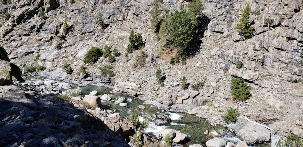
Once we entered Kings Canyon the scenery around us took a different turn with water flowing from the Canyons and the trail running along the water stream for a long time. Our first break point for the day was the the intersection of JMT and Goddard Canyon trail. The hike from Piute pass trailhead to Godard Canyon trail junction was a gradual ascent along the water stream with very few shaded sections. This was the section, where we met another trail friend (Van) of ours, with whom we would eventually take a picture on top of Muir Pass.
It took us about 4 hours to cover the first 5.3 miles until we reached Goddard Canyon Trail junction. We took our lunch break here, and were getting ready for what was ahead of us. The trail which was gradually ascending up until this point, started to gain elevation at a faster pace. About half a mile into the hike from our break point we realized the climb ahead of us was not an easy one until we reached Evolution Creek.
This was still the first day with our overweight backpacks and the ascend up to the Evolution creek crossing was brutal. It took us an hour to get up to Evolution creek crossing, where me and my buddy had to split. The creek crossing can get dangerous early in the season, but there was not a lot of water when we arrived. My buddy decided to cross the creek right along the trail, and I was hesitant to remove my shoes and cross with my blisters, so I proceeded ahead along the creek further ahead. About half a mile ahead, the side trail would eventually end and force me to cross the creek. I ended up crossing the creek where the water levels were even lower, and took a short break to enjoy the beautiful Evolution Meadows.
After a short break at the Evolution Meadows I continued on the trail until it joined back JMT, and waited to see if my buddy would show up. I waited for about 10 minutes before proceeding further, and it was the right decision as I would eventually end up meeting my buddy at the McClure Meadow ranger station. After the steep ascent we took to reach Evolution creek crossing, the rest of the trail didn’t seem so much harder, but was still a gradual ascent.
As I got closer to McClure meadow ranger junction, I finally passed by a couple of other hikers who were headed North and confirmed that my buddy was right ahead and was waiting for me. I would reach McClure meadow ranger station in the next 15 minutes and we continued to proceed further before we could camp for the day.
Our goal was to get as much closer to Evolution Lake and camp at the very last camping spot before the ascent towards Evolution Lake. About a half mile into the hike from McClure meadow ranger station, we would eventually pass the Purple Zombies, and would continue along with them for the rest of the day. We reached our campsite at 6:15 pm and had plenty of sunlight left to discuss our plans for the rest of the trip. As we started to share our itinerary with the Purple Zombies they realized that they could stick to our itinerary as well, and skip their planned food resupply at Onion Valley trailhead. We had early dinner and spent the rest of the time enjoying the beautiful sunset!
Day 8 Summary ~ 13 miles, 2000 feet elevation gain
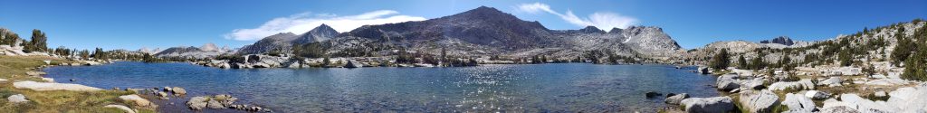
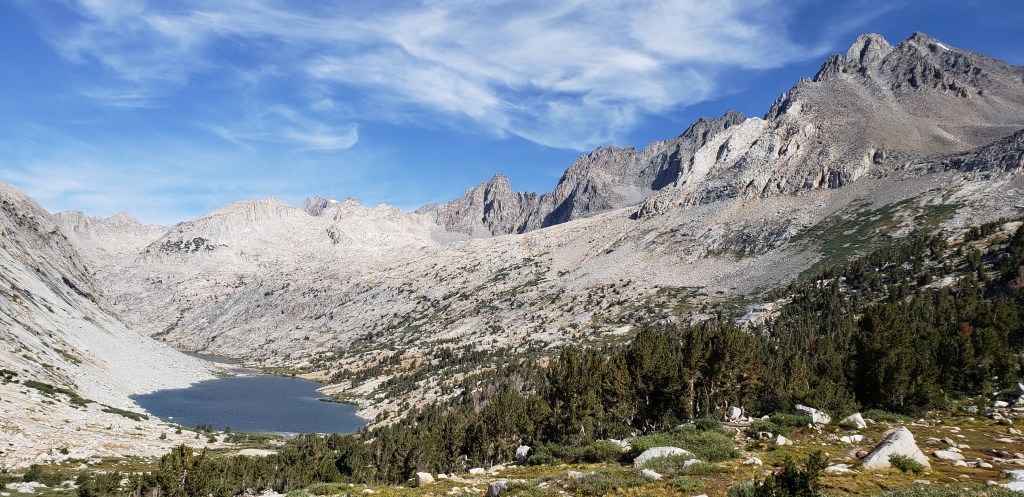
Day 9 – It was supposed to be an iconic day, as we would finally end up seeing Muir Hut, and the hike up to Muir Pass was my personal favorite of the whole trip. Our day started with quite a few hikers passing by our campsite (it was close to the trail) before we started to get go! The initial stretch for the day was an ascent up to Evolution Lake, which set us up for the rest of the day. The whole Evolution valley; in around Evolution Meadow, Evolution Lake, Muir pass are so beautiful that you would want to go back time and again! It took us a good 90 minutes to get up to Evolution Lake, and the views of the lake were simply amazing!

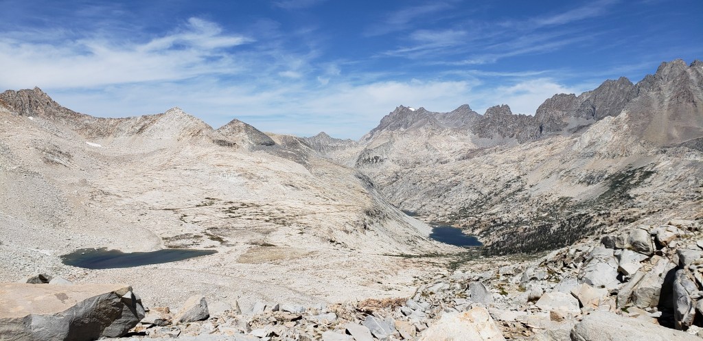
We spent a good amount of time in and around Evolution Lake before proceeding along as we could not get enough of this place. The trail is much flatter until you get to the other side of Evolution Lake, and can spot Sapphire Lake at a distance. The trail starts to ascend gradually alongside of Sapphire lake, and you cannot, but stop and enjoy the views! This will go down as the most Picturesque day as well, because of the all the breathtaking scenery we passed by on our way to Muir Pass.
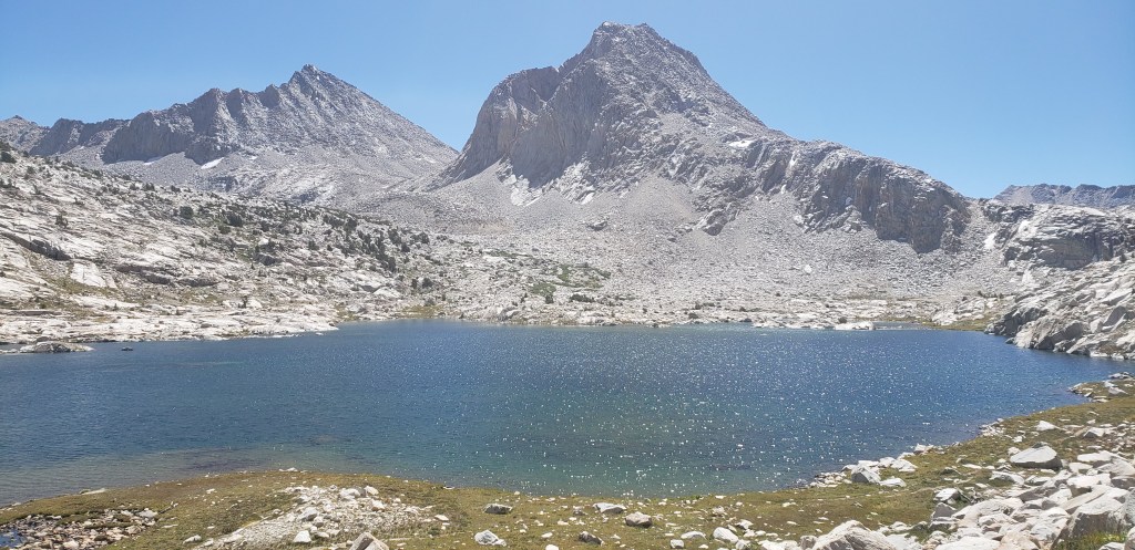
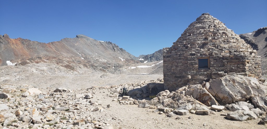
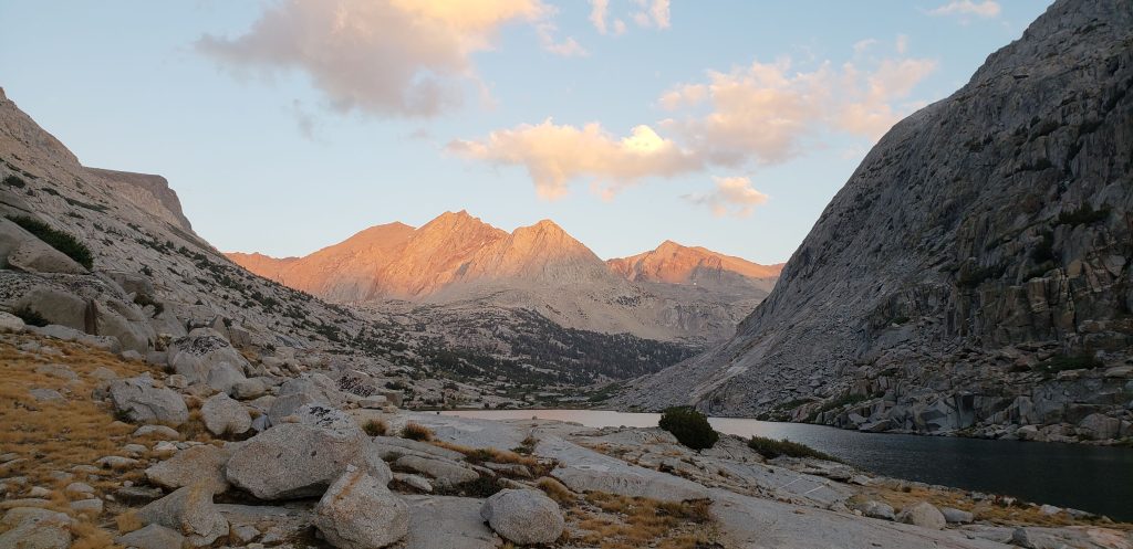
As we proceeded along the trail from Sapphire Lake, we were looking all around us to try and spot the Muir Hut which was supposed to be the highlight of the day. At about 4 hours into the hike when we could see Muir Pass, it was time for our day break. We were trying to find a shaded spot for our break, but found a better one right along the scenic views of Wanda Lake. Wanda Lake was a cherry on top of all the beauty we had experienced throughout our day. The views of the lake were simply amazing, and can’t be expressed by a photo!
As we took our break we could easily spot Muir Pass and see what was ahead of us. What seemed like a flat trail from Wanda Lake to Muir Pass was much harder with the sun hitting us directly on the face. Slowly and steadily we made our progress towards Muir Pass and eventually got to the pass in about 90 minutes from Wanda Lake. The final stretch of Muir Pass was brutal on our legs, but was also bitter sweet as we could spot Muir Hut from a distance. We didn’t spend a lot of time on top of Muir pass, but did take some great pictures. This is also the place where we took our picture with Van, who we met the previous day.
After our brief break and picture session we decided to head down from Muir Pass. There is a reason why this was a Picturesque day; as beautiful as it was to hike up Muir Pass, it was also great to descend, as the views did not disappoint us. We started to gain pace as we descended down, and eventually could spot the Purple Zombies before our final descent towards Canyons and meadows. Our initial plan was to camp at Starr Camp, but we ended up going a little further as there was enough sunlight left. We ended up camping at first campsite in Big Pete Meadow.

As we had some sunlight left, we quickly setup our camp and decided to clean ourselves so we could feel refreshed. We went to bed thinking about the day, and I am still in love with this as I write this 6 months down the line!
Day 9 Summary ~ 12.5 miles, 2000 feet elevation gain
Day 10 – With an iconic day behind us we were in good spirit (always) and were looking forward to the Golden day of the hike. This did not end up being the most dreadful day, but was a close second only because going up Glenn Pass was very very brutal! Our morning routine had a little guest today as we had camped at Shark Camp; a camping spot where a rock formation with a little creativity was converted to look like a shark.
Our initial stretch for today was all downhill as we crossed Le Conte canyon until we reached the intersection of Middle fork kings river trail. The downhill hike was a welcome rest for our feet, and we crossed a few beautiful meadows along our descent. We took our lunch break at the intersection and were all set to head towards the renowned Golden Staircase.
The stretch of trail from Middle fork kings river junction was a gradual ascent for close to 5 miles before ending up at the foot of Golden Staircase. Along our journey towards Golden Staircase we met up with two other trail acquaintances who were attempting JMT for the second time. They had been on the trail for much longer, and had no means of communication to the outside world. It was time for a good samaritan deed, so I ended up offering to send a text to their family after I meet up with my buddy using our Garmin InReach. Garmin InReach was the best thing to keep our friends and family updated and make them feel secure when we were in midst of wilderness.
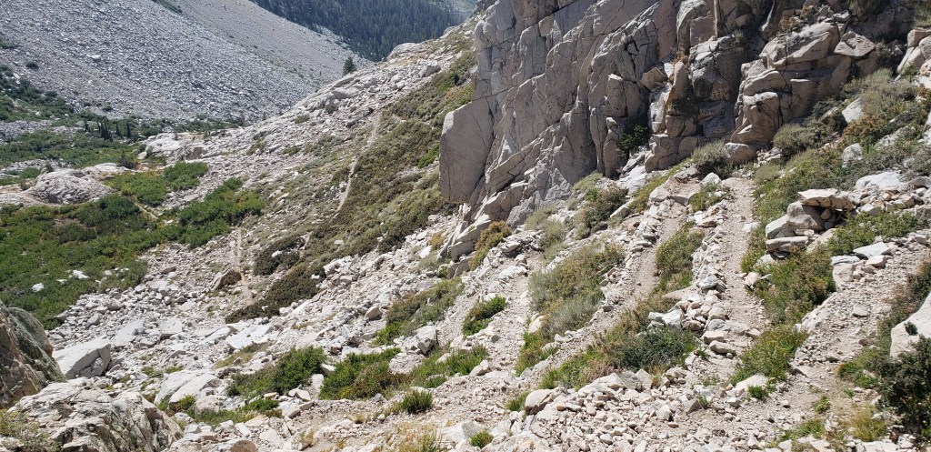
As I approached the foot of Golden Staircase I could see my buddy waiting for me, and along with him were the Purple Zombies getting ready to take on the Golden Staircase. I stopped here for a few minutes before I could head up the dreadful Golden Staircase. The next 2 miles of hike along Golden Staircase was adventurous, beautiful and exhausting. I am still amazed as to how we were able to climb up the Golden Staircase before it could get dark, and we could fall over to do it all over again! Golden Staircase ascends about 1200ft through a series of switchbacks that get harder and harder as you make your way through them.
It took us a good 2 and half hours of grueling hike to make it through the Golden Staircase. What lies on the other side of Golden Staircase, is what makes the climb that much more rewarding. The mesmerizing Palisade Lakes make their way as you climb up the Golden Staircase, to rejuvenate a tired soul. Our campsite for the day was the first spot around Palisade Lakes and we found a good camping spot overlooking one of the Palisade Lakes. We had enough sunlight left, and ended up taking a lot of pictures and talking to a few fellow campers who had camped nearby.
As the sun set beyond the Palisade Lakes everything turned Golden and made the views much more beautiful. We finished our dinner quickly, before it could get too cold. My buddy was still in awe with the view and stayed out a little while longer, only to drag the Purple Zombies out of their tents to see the amazing Night-sky filled with stars! I ended up staying inside and keeping myself warm, as I overheard the commentary about how beautiful it was.
Day 10 Summary ~ 11 miles, 2500 feet elevation gain
Day 11 – We woke up to a chilly morning and could not wait to get our breakfast going so we could warm ourselves up. We were getting better with time (if only 15 minutes) and were all set for the stretch of passes that we would go over the next 5 days. Like the famous saying “One Apple a day keeps the doctor away”; I came up with a better one “One pass a day, gets better everyday”. Each pass was more challenging than the other one, and we had all the harder ones ahead of us. We started with a gradual ascent along the Palisade Lakes for about 2 and half miles before gaining more elevation with distant view of Palisade Lakes.
As we continued our ascent towards Mather Pass, the Boston Guys (remember our trail friends from Reds Meadow) decided to show up, and were pacing through like it was a Boston Marathon and they had a time to beat. We would meet them one final time towards the end of the day, and never saw them again. It took us about 2 hours before we could get to the vicinity of Mather Pass. We took a brief break before we started to head towards the pass. Mather Pass is a technically challenging pass as the trail is much narrower and the sharp granite rocks make your hike that much more difficult. We got to the top of Mather Pass around noon and would not meet anyone on top of it.
After our customary photo session on Mather Pass, we started to descend and proceed towards an endless stretch of flat trail which would make the day tiring. After the steep descent from Mather Pass, the trail gradually descends for about 5 miles. We did not take an official lunch break today as the trail was much flatter, and we continued on our own pace until reaching the ascent towards Bench Lake. What made our next 4 days more challenging was the ascents that we had to do at the end of the day, so we could get closer to the passes. The only thing we had going during our descent was the beautiful views around us and the first signs of cloud!
We descended for about 2100 ft before making our final ascent for the day. The ascent towards Bench Lake was short and steep, and we were inching closing towards our campsite for the day. From Bench Lake junction the trail was much flatter and I was walking in the vicinity of the Purple Zombies and my buddy. Our initial plan was to camp at the first campsite at Lake Marjorie where we met the Boston guys for one last time, but we decided to proceed further. We ended up camping at one of the very last campsites on Lake Marjorie. It was hard to find a good flat spot, but eventually found a couple of them at a higher ground. Even though we had enough sunlight left, it was getting colder because of the strong winds making an impact. We quickly finished our dinner and made our way inside the tent. The winds wouldn’t stop until early morning hours, which even caused a small rockslide on the other end of Lake Marjorie.
Day 11 Summary ~ 14 miles, 2500 feet elevation gain
Day 12 – The winds from last night wouldn’t stop until early morning hours which meant we slept in late, and were not out of our tents until 8 am. As we scrolled out of our tent we could see some fantastic views of Lake Marjorie with the sun making its presence felt. Since we camped at one of the last campsites on Lake Marjorie it meant that Pinchot pass was not too far. With views of Lake Marjorie ahead of us we started proceeding towards Pinchot pass. We went past a few other lakes and a series of red mountains before we could see Pinchot pass in our vicinity. The ascent over Pinchot pass was relatively short and we reached there in less than 90 minutes from Lake Marjorie.
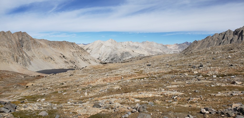
As we got to the top of Pinchot Pass the winds started to pick up again, which made our stay on top of Pinchot pass very short. We quickly clicked a few pictures and started descending down Pinchot Pass. From Pinchot Pass we had a long descent towards Woods Creek Trail junction. It took us about 4 hours to descend the close to 8 mile hike towards Woods Creek Trail junction, which served as an entry point to people doing the Rae Lakes loop. From Woods Creek Trail junction one could reach the Roads End of Kings Canyon National park within a days hike. As we approached the junction we had already caught up to the Purple Zombies, before all of us decided to cross the suspension bride taking our turns. We took our lunch break after crossing the suspension bridge, while watching over our shoulders for possible bear activity.
From Woods creek junction we had another 4 miles to go before we could get to our campsite for the day; which was Dollar Lake. We were a little exhausted with the long descent from Pinchot pass which made the ascend towards Dollar Lake challenging. The trail gains gradual elevation as you depart from Woods Creek junction. We came across quite a few Rae Lake loop hikers who were either finishing up the trip or going towards Rae Lakes. Halfway into our ascent towards Dollar Lake, my pace slowed down, and I was walking alone with my buddy and Purple Zombies making their presence felt at distance at occasional times. By the time I got to Dollar lake my buddy had already scoped out a beautiful camping spot right by the lake. The water outlet from Dollar Lake was not so cold so we decided to cleanse ourselves in the water. As the sun started to set we saw first signs of mosquitos on the trail (proximity to Dollar Lake may be a reason), which made us hurry through our dinner and run into our tents before it was dark.
Day 12 Summary ~ 13.2 miles, 2700 feet elevation gain
Day 13 – We had our fair share of challenging climbs over the last few days, but today was going to be the most challenging day of the entire hike. It was not the distance nor the elevation gain we had for the day, it was all due to the beautiful and dreadful Glenn Pass. We started our day with a strolling hike towards Rae Lakes, and knew that it was going to be a relatively flat stretch until we got there. Rae Lakes is the most popular hiking section along the JMT and it did not disappoint us. From the get go of its initial sight, the entire trail along the section of Rae Lakes is amazingly beautiful, and will take your breath away. The gorgeous views are a testament to why so many people love camping at Rae lakes. It took us a little over 90 minutes to reach the end of Rae lakes section and start the ascent towards Glenn Pass.
On map, Glenn pass is only 1.9 miles from the end of Rae lakes (intersection of sixty lakes basin trail) and close to 1600 ft climb. The first half mile will take you though some gradual elevation gain, before you get to a section of switch backs which go through some steep elevation gains, before flattening out. Most of the trail until you reach Glenn pass is not shaded, which meant the sun was hitting you with all its power and all you could do was to proceed with one step at a time.
Right when you think that it cannot get any worse than the section of switch backs you just completed, you are dealt with another section of steep switch backs along the side of Glen Pass which take a toll on your spirits. As we continued our climb towards Glenn pass, we met two other trail friends who served as a challenge for my buddy. We never officially gave them a trail name, but I would call them “Fast and Furious”. The trail is narrow with some sharp granite rocks, and you will need to tread carefully at certain places so you won’t slip and fall. The combination of steeper switch backs, the narrow trail, and the sun all made it for a dreadful climb up Glenn Pass. After making it to the top, we would officially call it the “Toughest Pass” till day, but that name stuck on even after completing JMT.
We were exhausted by the time we reached Glenn Pass, and were ready for a break. It got crowded over the pass, so we decided to head down after taking a few good pictures on both sides of the pass. The trail was equally steeper while descending Glenn Pass, so we had to be extra cautious with gravity pulling us down. We quickly descended towards Charlotte lake before reaching the intersection of Kearsarge Pass. We continued to head towards Bubbs Creek Trail junction before we could break for lunch. I had read previous reports of bear activity in the area, and all the extra precautionary signs didn’t make me feel comfortable.
The descent from Glenn Pass ends at Bubbs Creek trail junction, from where you can reach Roads End as well. We were finally in Lower Vidette Meadow before we started to gain elevation again, this time heading towards our campsite which would be closer to Forester Pass. As I continued to gain elevation I noticed something moving at a distance, and to my surprise that was the only bear we would see on our hike. I quickly raced towards my buddy to make him aware of the bear, and we headed our own way towards higher ground, while the bear decided to stick to its area around the lower ground.
Our initial plan for the day was to get as close to Forester Pass as possible so it would make the ascent on Forester easier, but also let us cover more mileage the next day so we could end as per our schedule. The Purple Zombies caved in early for the day, as me and my buddy proceeded further. As we started to lose sunlight more rapidly my buddy raced ahead of me to find a camping spot before it could get dark. Tired and exhausted by the dreadful climb up the Glenn Pass, I finally reached our planned camping spot. I was scouting for my buddy, when I spotted him speaking to familiar faces; Lightning and Thunder had struck us again, and their sight was a happy ending to a tiring day. They had taken a detour towards Onion Valley, and were still able to keep their pace ahead of us. We talked for a bit, and eventually ended up camping for the night.
Day 13 Summary ~ 13.5 miles, 3200 feet elevation gain
Day 14 – We could smell our JMT completion as we went to bed the last night. We had rejuvenated energy as were were looking forward to completing the hike in the next 2 days. We expected to start our day early so we could get to Crabtree Meadow, but we couldn’t brave ourselves to get up earlier. Our first stop for the day was Forester Pass; the last official and highest pass on JMT. Our day started with a gradual ascent towards Forester Pass. There were quite a few people who had camped around us, and everyone were either going up Forester pass or going away from it. As we ascended gradually, “Fast and Furious” would overtake us and we would not meet them until later in the day.
After an initial gradual ascent, the trail takes a flatter stretch before ascending over a steep section of single line trail that intimidates any brave soul. The trail picks up greater elevation from this point until you reach Forester Pass. About halfway through this section the Purple Zombies would eventually catch up to us, as we took constant breaks on our ascent. We would eventually go along with Purple Zombies, and ended up on Forester Pass one after the other. As we reached Forester Pass, we felt a sense of accomplishment, but knew the journey was still incomplete. We made a lot of trail acquaintances on Forester Pass, and descended the trail with one of them for the day.
It took us about 2 and half hours to reach Forester Pass, and we spent a good 30 minutes on top of the pass before deciding to descend down. This is the last time we would cross paths with Purple Zombies on the trail, as we would end up completing our hike at different times. We never got to say our official goodbyes, but their company throughout the trail so far was much appreciated. As we descended down we could feel a change in scenery (entered Sequoia National Park) and all those beautiful lakes we passed all these days would finally disappear.
We continued our descent towards Shepherd Pass trail intersection, and took our day break here before proceeding further. From Shepherd Pass Trail intersection, the trail takes a gradual ascent before descending towards High Sierra Trail junction. As we descended towards the High Sierra Trail junction, we came across a Second ranger who would eventually check our permits, before letting us proceed. We were getting tired with the numerous ascents and descents, and were sure we could not make it to Crabtree Meadow by sunset. We started to make secondary plans and decided to camp closer to Crabtree Meadow.
We walked by “Fast and Furious” about half a mile past the High Sierra Trail junction. We continued to gain elevation again as we proceeded towards Crabtree Meadow. Our original plan was to camp within a mile of High Sierra Trail junction, but we ended up hiking up to Sandy Meadow before stopping for the day. We would not realize Sandy Meadow was the last campsite before Crabtree Meadow, until we ran into a fellow camper who would caution us, and we were very thankful. Our campsite at Sandy Meadow was pretty isolated, and we did not enjoy its solidarity until the next day! We went to bed with dreams of completing JMT the next day, which would eventually be a reality!
Day 14 Summary ~ 14.5 miles, 3200 feet elevation gain
Day 15 – We woke up feeling great, and unable to believe that this was the day that would be etched in our lives for eternity! This was the penultimate day of our hike, our most glorious day, the day we would have officially through hiked the JMT. There were a lot of mixed feeling going on in my head; the excitement of finishing JMT, the joy of being able to accomplish it and the happiness of being able to go back to my wife. In preparation to ascend Mount Whitney and descend down to our campsite for the night, we decided to start earlier than usual, and were out on the trail at 7:45 am (a personal record!).
Our initial part of the hike was a descend towards the Crabtree Meadow junction, before JMT would split from PCT. From the junction the trail was pretty much flat until you reached the Crabtree Ranger Station. As we went past the ranger station the trail started to ascend gradually, and it was the sign of elevation gain that would not end until we reached Mount Whitney. Our first stop for the day was Guitar Lake where we were supposed to fill water for rest of the trail until we reached the campsite tonight. As we started proceeding towards Guitar Lake we passed by Timberline Lake which had some beautiful view of the meadows and mountains. The trail had gradual elevation gain until we finally reached Guitar Lake around 10:30 am.
We took a quick snack break at Guitar Lake, and refilled our water supply before proceeding further. With the views of Guitar Lake behind us, we slowly started to gain elevation until we reached the range of Mount Whitney mountain. Once you are on Mount Whitney mountain range, you will have to go through a series of long switchbacks before eventually ending up at the Trail Crest junction. The long switchbacks make for a grueling ascent, and the trail can get pretty narrow at certain points where you will need to tread carefully. My buddy had picked up pace through this section, and was waiting for me at Trail Crest junction. As I approached Trail crest, I started to see a flurry of people either taking rest or proceeding towards Mount Whitney.
We decided to take a short break at Trail Crest junction before proceeding further. Having been to Mount Whitney before, this part of the trail was no strange to us, and so were the Marmots at Trail Crest junction. We decided to leave all our heavy gear and Bear Canisters at the junction, but carry our backpacks so Marmots wouldn’t chew through them for food. About a mile into the hike from Trail Crest junction, “Fast and Furious” made their appearance from behind and headed past me as I was taking breaks in between. My Buddy on the other side had one goal for the day; get to Mount Whitney before “Fast and Furious” could get there, and he was eventually able to make it before them.
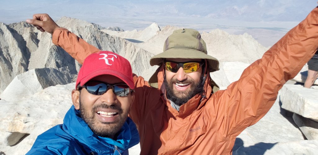
I was taking my time to get through the final part of the ascend towards Mount Whitney, and would eventually reach about 30 minutes after my buddy got there. As I approached the summit of Mount Whitney, I could spot my buddy, and the first thing we did was to hug it out! We had done it, the goal of thru hiking JMT was done, we were elated, we were happy, we were beyond words, but expressions spoke for themselves! To commemorate our hike, I had packed a flask of finest Whisky that would end my drinking drought of 9 months, and who better to share it than your buddy who was part of it, and our trail friends “Fast and Furious”.
As we sat there, we soak in the glory and started to reflect back on how big of a journey it was! It was Day 3 when I had second thoughts of quitting because of my blisters, and here I am after 12 days and as many blisters on both my feet, enjoying the best feeling one could ever imagine! We spent a better part of an hour on top of the summit and started to descend down around 4:30 pm. We gained pace and raced through to reach the Trail Crest junction in about an hour. I needed a break to catch my breath at Trail Crest so we decided to take a quick break. As we sat down at Trail Crest I met a fellow hiker who had forgot to refill water on his way up, and was concerned. My good samaritan instincts kicked in, and I ended up sharing my extra pack of water with him, as I was heading down and knew would find water in the next 2 miles.
As we proceeded from Trail Crest junction, we would eventually go by Trail Pass, which was the highest pass on the hike. From Trail Pass, we had to take the infamous “99 switchbacks” to get to Trail Camp which was going to be our campsite for the night. I took my time descending down the switchbacks as my buddy raced through them like there was no tomorrow. Our trail friends “Fast and Furious” were kind enough to hold a camping spot for us, so we wouldn’t have to struggle to find one. There were so many people at Trail Camp, that it no longer felt like Wilderness, and we had our solidarity with nature for the last time the previous night! I ended up going to bed, reminiscing the past 15 days and how it had made an impact on me.
Day 15 Summary ~ 14 miles, 4000 feet elevation gain
Day 16 – We had about 8 miles left to go, and had arranged for a taxi ride to drop us from Whitney Portal to Tuolumne Meadows; thanks to Garmin InReach and our friend back home who was able to co-ordinate it for us. We woke up to the same chatter we had spent our night, and were all set to end our trip. Our trail friends “Fast and Furious” stopped by and we exchanged information to stay in touch, and went on their way. We were not too far behind and started to descend down in the next 30 minutes. About 2 and half hours later is how my quest to write all this started!

Leave a comment