If you want to mesmerize yourself with the best 360-degree views of what Yosemite has to offer, then Mount Hoffmann hike is for you. I knew the views of May Lake were beautiful, but getting to Mount Hoffmann was cherry on the top for this hike. The hike up to Mount Hoffmann is short, but challenging and will test your calves when going up, and your knees coming down.
There is more than one trail that leads to May Lake from where you can get to Mount Hoffmann. We chose the shortest route, which starts from the official May Lake trailhead, which is 2 miles off Tioga Road next to Snow Creek. At only 5.6 miles (not true) of official trail length to Mount Hoffmann, this is probably one of the shorter hikes to some amazing views. We were greeted by numerous mosquitos at the May Lake trailhead as we started our hike around 8.15 am.
There were quite a few vehicles at the trailhead, but barely anyone except for two rangers who were on their way to Mount Hoffmann. The trail ascends gradually from the get go and its shaded for the most part up until May Lake. The rangers started about 10 minutes ahead of us, and we caught up to them in no time. This is when I realized I had seen those rangers on my John Muir Trail hike, they were checking permits around the Vogelsang lake junction. I stopped for a bit and had a good conversation with them, and they were thrilled that people remember seeing them. The rangers did remember a few groups, but acknowledged it was practically impossible to remember everyone they come across.
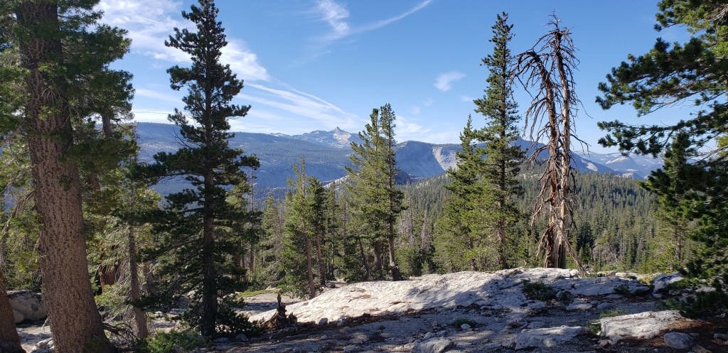
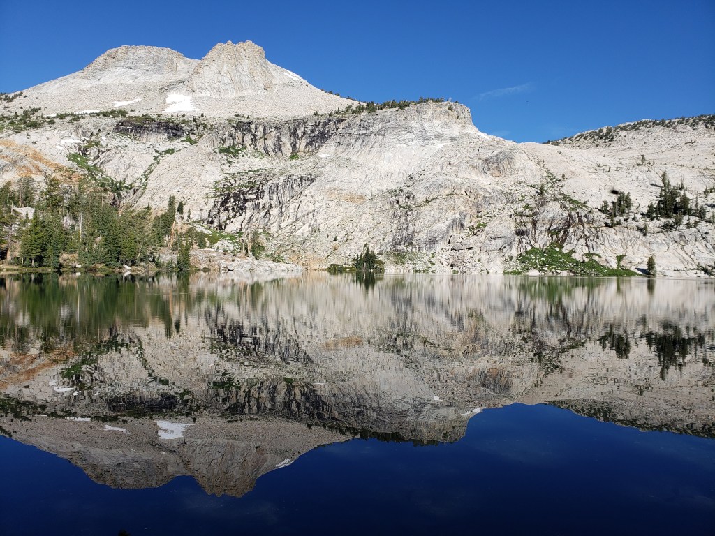
After our candid conversation with the rangers, we continued on our path towards May Lake. The trail soon opens up to some beautiful views of Mount Lyell. It took us close to 45 minutes before we reached May Lake. There were quite a few people camping at May Lake, and almost everyone had mosquito nets on their heads. We spent the next 30 minutes or so enjoying the views of May Lake, and taking good pictures of the mountains reflecting onto May Lake. The reflection of mountains onto May Lake is probably the next best thing to Evolution Meadows or Cathedral Lake.
Once you get to May Lake, there is not an official trail that leads to Mount Hoffmann. After checking with the rangers we started following the trail to the left, which goes by May Lake until you reach the very end. You keep following the trail for the next mile or so, before you have to make your ascent towards the mountains that were reflecting onto May Lake. There is not a marked trail but keep following the Cairns that make for a good trail marking. We came across a family of four (two kids) who were hiking Mount Hoffmann and followed us to the top.
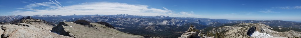
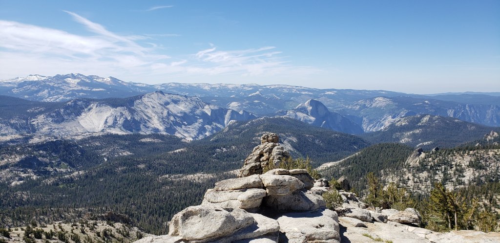
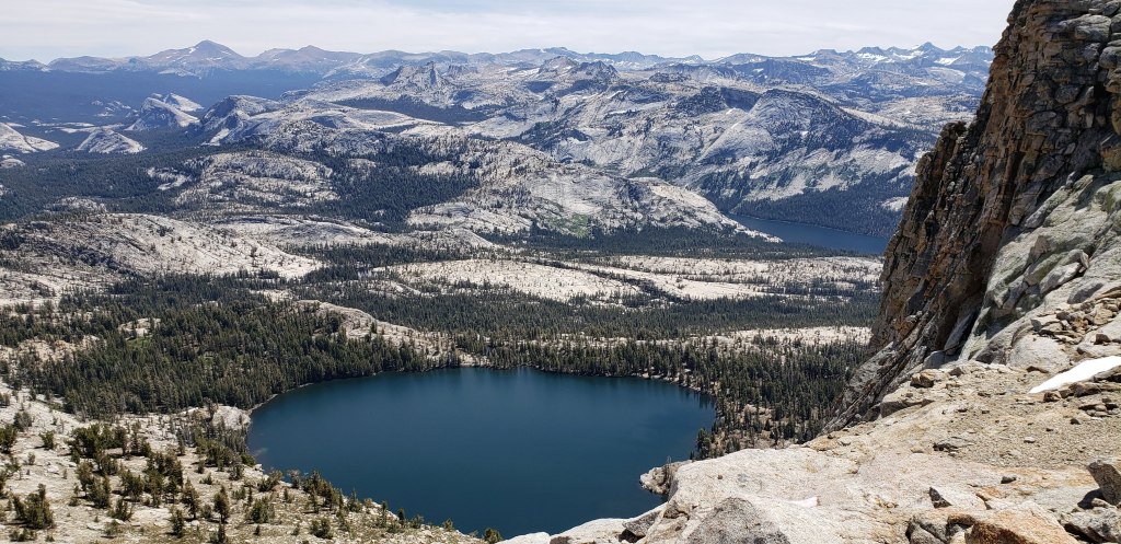
This part of the trail is steep and flattens at the top, where you can spot Mount Hoffmann. We originally thought that the reflection onto May Lake was Mount Hoffmann, but you will not see Mount Hoffmann until you reach this point on trail. Mount Hoffmann has an antenna on top of it, which distinguishes itself from the neighboring mountains. The trail flattens for the next half mile or so once you spot Mount Hoffmann. It took us close to 2 hours before we ended up at the base of Mount Hoffmann. The last part of the trail to Mount Hoffmann is a class 2 scramble. Make sure you steer away from the cliffs, as they are pretty steep on the other side of your climb. We reached on top and were amazed by the views one could enjoy from Mount Hoffmann. From the top of Mount Hoffmann one can spot almost every iconic place that Yosemite has to offer (Half Dome, Clouds Rest, Tenaya Lake, Yosemite Valley to name a few)
We spent a better part of the next hour or so on top of Mount Hoffmann clicking photos, guiding people to get up, and soaking in all the views that it had to offer. As we started to head down the two rangers had made their way to the base of Mount Hoffmann. With abundant of time in front of us, the rangers recommended a short detour from where we could spot May Lake. We took the rangers advice and continued on the trail to the left from the base of Mount Hoffmann towards the views of May Lake. We came across a patch of the infamous pink snow, and did not realize what it was until we read about it the next week. We got to the end of this side trail where the views of May Lake from the top were simply breathtaking.
After enjoying the views of May Lake we started our descent towards the main trail that would lead us back to May Lake. Though the trail was steep when getting on top, we felt its real steepness as we descended down the section of trail that was marked with cairns. It took us about 30 minutes to descend down the trail and stop for our lunch break right before May Lake. We took our time and started planning our after hike activities as we had plenty of time left in the day. As we reached May Lake on our descent there were a lot of day hikers who were either heading up to Mount Hoffmann or were enjoying their hike until May Lake. We reached the trailhead at about 2:15 pm, and it took us close to 6 hours in total to finish the hike.
Difficulty – Hard Insanity Level – 3 Distance ~ 8 to 9 miles Elevation ~ 2200 ft Time ~ 4-6 hours
Directions: May Lake Trailhead – May Lake trail – May Lake – Mount Hoffmann trail (left of May Lake) – Mount Hoffmann – Mount Hoffmann trail – May Lake – May Lake trailhead

Leave a comment